U.S. DOT aims geospatial data at freight transport optimization
Last updated Jul 14, 2010 — 70 views NAVTEQ says the U.S. Department of Transportation will use its map data across a wide range of research and analysis programs aimed at bringing advanced technologies into the nation’s transportation system. Initially, the company’s geospatial information and services will be incorporated into GeoMiler, a route-modeling application aimed at optimizing the performance of the nation’s freight transportation system.
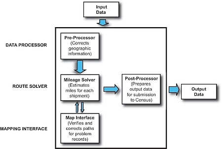
The GeoMiler application is a software tool developed by the U.S. DOT’s Research and Innovative Technology Administration, Bureau of Transportation Statistics (RITA/BTS), said to generate multimodal routing models to help researchers better estimate freight travel. The tool’s integration of core GIS technology and its modeling approach (see figure below) make it useful for optimizing any multimodal freight movement at all geographic levels, claims RITA/BTS.

GeoMiler functional components
(click image to enlarge; source: US-DOT RITA/BTS)
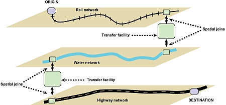
According to RITA/BTS, GeoMiler uses current Geographic Information Systems (GIS) technology to plot the likely routes used for each shipment. The estimated routes are then used to calculate mileage from the true origin to the true destination for each freight shipment, even when more than one freight mode is used (see figure below).

Routing of a multimodal shipment from origin to destination
(click image to enlarge; source: US-DOT RITA/BTS)
“Access to a complete, accurate nationwide map dataset will help the U.S. DOT develop and deliver research and analysis more efficiently and facilitate greater geospatial transportation collaboration,” stated NAVTEQ vice president Roy Kolstad.
Further information regarding the GeoMiler application is available on the RITA/BTS website, here.